

【中英文對照】白皮書簡寫本:中菲南海有關(guān)爭議的事實(shí)與觀點(diǎn)
發(fā)布時間:2016-07-13 18:02:31 | 來源:中國翻譯研究院 | 作者: | 責(zé)任編輯:李瀟| 南海諸島是中國固有領(lǐng)土 | Nanhai Zhudao Are China's Inherent Territory |
| 中國南海諸島包括東沙群島、西沙群島、中沙群島和南沙群島。中國最早發(fā)現(xiàn)、命名和開發(fā)利用南海諸島及相關(guān)海域,最早并持續(xù)、和平、有效地對南海諸島及相關(guān)海域行使主權(quán)和管轄。明清時期形成并流傳至今的《更路薄》記錄了中國人民在南海諸島的生活和生產(chǎn)活動,以及對南海諸島的命名。中國對南海諸島的主權(quán)和在南海的相關(guān)權(quán)益,是在漫長的歷史過程中確立的,具有充分的歷史和法理依據(jù)。 | China's Nanhai Zhudao (the South China Sea Islands) consist of Dongsha Qundao (the Dongsha Islands), Xisha Qundao (the Xisha Islands), Zhongsha Qundao (the Zhongsha Islands) and Nansha Qundao (the Nansha Islands). China is the first to have discovered, named, and explored and exploited Nanhai Zhudao and relevant waters, and the first to have continuously, peacefully and effectively exercised sovereignty and jurisdiction over them. Geng Lu Bu (Manual of Sea Routes), which came into being and circulation in the Ming and Qing Dynasties and has been handed down and is still in use even today, showed that the Chinese people lived and carried out production activities on, and how they named Nanhai Zhudao. China's sovereignty over Nanhai Zhudao and relevant rights and interests in the South China Sea have been established in the long course of history, and are solidly grounded in history and law. |
| 1933年,法國曾一度侵入南沙群島部分島礁,制造了“九小島事件”。中國政府采取一系列措施捍衛(wèi)主權(quán)。1935年中國水陸地圖審查委員會編印并公布了《中國南海各島嶼圖》。 | In 1933, France invaded some islands and reefs of Nansha Qundao, creating the "Incident of the Nine Islets". The Chinese government took a series of measures to defend China's sovereignty over Nansha Qundao. China's Committee for the Examination for the Land and Sea Maps compiled and published Zhong Guo Nan Hai Ge Dao Yu Tu (Map of the South China Sea Islands of China) in 1935. |
| 日本在侵華戰(zhàn)爭期間曾非法侵占中國南海諸島。隨著世界反法西斯戰(zhàn)爭和中國人民抗日戰(zhàn)爭的推進(jìn),中、美、英三國于1943年12月發(fā)表《開羅宣言》鄭重宣布,日本必須將所竊取的中國領(lǐng)土歸還中國。1945年7月,中、美、英三國發(fā)表《波茨坦公告》,其中第8條明確規(guī)定:“開羅宣言之條件必將實(shí)施。”1945年8月,日本宣布接受《波茨坦公告》無條件投降。 | Japan invaded and illegally occupied Nanhai Zhudao during its war of aggression against China. With the advance of the World's Anti-Fascist War and the Chinese People's War of Resistance against Japanese Aggression, China, the United States and the United Kingdom solemnly demanded in the Cairo Declaration in December 1943 that all the territories Japan had stolen from the Chinese shall be restored to China. In July 1945, China, the United States and the United Kingdom issued the Potsdam Proclamation. That Proclamation explicitly declares in Article 8: "The terms of the Cairo Declaration shall be carried out." In August 1945, Japan announced its acceptance of the Potsdam Proclamation and its unconditional surrender. |
|
| 1943年11月,中、美、英三國領(lǐng)導(dǎo)人在埃及開羅會晤(從左至右,蔣介石、羅斯福、丘吉爾)。 The leaders of China, the United States and the United Kingdom met in Cairo in November 1943 during World War II (left to right: Chiang Kai Shek, Franklin D. Roosevelt, Winston Churchill). |
|
| 1943年12月,中、美、英三國政府聯(lián)合發(fā)表《開羅宣言》,規(guī)定日本必須歸還其所竊取的中國領(lǐng)土。 China, the United States and the United Kingdom jointly released the Cairo Declaration in December 1943, demanding Japan to restore to China all the territories that it had stolen from the Chinese. |


| 1946年11月至12月,中國政府派員分赴西沙群島和南沙群島,舉行儀式,重立主權(quán)碑。次年3月,中國政府在太平島設(shè)立南沙群島管理處。 | In November and December 1946, the Chinese government dispatched senior military and civil officials to Xisha Qundao and Nansha Qundao to resume exercise of authority over these Islands, with commemorative ceremonies held and sovereignty markers re-erected. In March 1947, the Chinese government established on Taiping Dao the Nansha Qundao Office of Administration. |
|
| 1946年12月,中國政府派接收專員及官兵在太平島上舉行儀式,收復(fù)南沙群島。 Chinese government officials arrived in Taiping Dao in December 1946, recovering the sovereignty over Nansha Qundao. |

| 1948年2月,中國政府公布《中華民國行政區(qū)域圖》,包括標(biāo)有南海斷續(xù)線的《南海諸島位置圖》。 | In February 1948, the Chinese government officially published Zhong Hua Min Guo Xing Zheng Qu Yu Tu (Map of the Administrative Districts of the Republic of China) including Nan Hai Zhu Dao Wei Zhi Tu (Location Map of the South China Sea Islands) on which the dotted line is marked. |
|
| 1948年2月,中國政府公布《中華民國行政區(qū)域圖》,包括標(biāo)有南海斷續(xù)線的《南海諸島位置圖》。 In February 1948, the Chinese government published Nan Hai Zhu Dao Wei Zhi Tu (Location Map of the South China Sea Islands). |

| 1949年10月1日中華人民共和國成立后,進(jìn)一步維護(hù)對南海諸島的主權(quán)和在南海的相關(guān)權(quán)益。 | Since its founding on October 1, 1949, the People's Republic of China has further upheld its sovereignty over Nanhai Zhudao and relevant rights and interests in the South China Sea. |
| 1958年9月,中國發(fā)布《中華人民共和國政府關(guān)于領(lǐng)海的聲明》,明確規(guī)定中國領(lǐng)海寬度為12海里,適用于中華人民共和國的一切領(lǐng)土,包括“東沙群島、西沙群島、中沙群島、南沙群島以及其他屬于中國的島嶼”。 | In September 1958, China promulgated the Declaration of the Government of the People's Republic of China on China's Territorial Sea, explicitly providing that the breadth of China's territorial sea shall be twelve nautical miles, and that such provisions shall apply to all territories of the People's Republic of China, including "Dongsha Qundao, Xisha Qundao, Zhongsha Qundao, Nansha Qundao and all the other islands belonging to China". |
| 1959年3月,中國政府在西沙群島的永興島設(shè)立“西沙群島、南沙群島、中沙群島辦事處”。 | In March 1959, the Chinese government set up on Yongxing Dao of Xisha Qundao the Office of Xisha Qundao, Nansha Qundao and Zhongsha Qundao. |
| 1983年4月,中國地名委員會受權(quán)公布南海諸島部分標(biāo)準(zhǔn)地名,總計(jì)287個。 | In April 1983, China Committee on Geographical Names was authorized to publish 287 standard geographical names for part of Nanhai Zhudao. |
| 1988年4月,第七屆全國人民代表大會第一次會議決定設(shè)立海南省,管轄范圍包括西沙群島、南沙群島、中沙群島的島礁及其海域。 | In April 1988, the Seventh National People's Congress decided at its First Session to establish Hainan Province with jurisdiction over Xisha Qundao, Nansha Qundao and Zhongsha Qundao and the relevant maritime areas, among others. |
| 1992年2月,中國頒布《中華人民共和國領(lǐng)海及毗連區(qū)法》,明確規(guī)定:“中華人民共和國的陸地領(lǐng)土……東沙群島、西沙群島、中沙群島、南沙群島以及其他一切屬于中華人民共和國的島嶼。” | In February 1992, China promulgated the Law of the People's Republic of China on the Territorial Sea and the Contiguous Zone. This Law explicitly states: "The land territory of the People's Republic of China includes […] Dongsha Qundao; Xisha Qundao; Zhongsha Qundao; Nansha Qundao; as well as all the other islands belonging to the People's Republic of China." |
| 1998年6月,中國頒布《中華人民共和國專屬經(jīng)濟(jì)區(qū)和大陸架法》,明確規(guī)定:“本法的規(guī)定不影響中華人民共和國享有的歷史性權(quán)利。” | In June 1998, China promulgated the Law of the People's Republic of China on the Exclusive Economic Zone and the Continental Shelf. This Law explicitly states: "The provisions in this Law shall not affect the historic rights that the People's Republic of China enjoys." |
| 2012年6月,國務(wù)院批準(zhǔn)設(shè)立地級三沙市,管轄西沙群島、中沙群島、南沙群島的島礁及其海域。 | In June 2012, the State Council approved the establishment of prefecture-level Sansha City with jurisdiction over Xisha Qundao, Nansha Qundao and Zhongsha Qundao and the relevant waters. |
|
| 2012年6月,國務(wù)院批準(zhǔn)設(shè)立地級三沙市。 In June 2012, the State Council approved the establishment of prefecture-level Sansha City with jurisdiction over Xisha Qundao, Nansha Qundao and Zhongsha Qundao and the relevant waters. |

| 第二次世界大戰(zhàn)結(jié)束后,中國收復(fù)南海諸島并恢復(fù)行使主權(quán),世界上許多國家都承認(rèn)南海諸島是中國領(lǐng)土。 | After the end of World War II, China recovered and resumed the exercise of sovereignty over Nanhai Zhudao. Many countries recognize that Nanhai Zhudao are part of China's territory. |
| 1952年,日本政府正式表示放棄對臺灣、澎湖列島以及南沙群島、西沙群島之一切權(quán)利、權(quán)利名義與要求。同年,由時任日本外務(wù)大臣岡崎勝男親筆簽字推薦的《標(biāo)準(zhǔn)世界地圖集》把西沙群島、南沙群島及東沙群島、中沙群島全部標(biāo)繪屬于中國。1972年,日本在《中日聯(lián)合聲明》中重申堅(jiān)持遵循《波茨坦公告》第8條規(guī)定。 | In 1952, the Japanese government officially stated that it had renounced all right, title, and claim to Taiwan, Penghu, as well as Nansha Qundao and Xisha Qundao. In the same year, Xisha Qundao and Nansha Qundao were all marked as belonging to China in the Standard World Atlas recommended by the then Japanese Foreign Minister Katsuo Okazaki with his signature. In 1972, Japan reiterated its adherence to the terms of Article 8 of the Potsdam Proclamation in the Joint Communiqué of the Government of the People's Republic of China and the Government of Japan. |
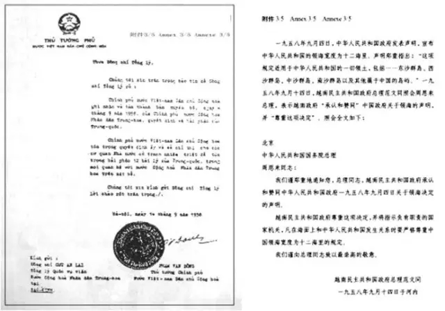
| 1958年9月14日,越南政府總理范文同照會中國國務(wù)院總理周恩來鄭重表示:“越南民主共和國政府承認(rèn)和贊同中華人民共和國政府1958年9月4日關(guān)于領(lǐng)海決定的聲明。” | On September 14, 1958, Prime Minister Pham Van Dong of the Vietnamese government sent a diplomatic note to Zhou Enlai, Premier of the State Council of China, solemnly stating that "the government of the Democratic Republic of Vietnam recognizes and supports the declaration of the government of the People's Republic of China on its decision concerning China's territorial sea made on September 4, 1958." |
|
| 1958年9月14日時任越南政府總理范文同照會中國國務(wù)院總理周恩來,承認(rèn)和贊同中國關(guān)于領(lǐng)海決定的聲明。 The then Vietnamese Prime Minister Pham Van Dong sent a diplomatic note to Chinese Premier Zhou Enlai on September 14, 1958, recognizing China's territorial sea. |
| 1987年3月17日至4月1日,聯(lián)合國教科文組織政府間海洋學(xué)委員會第14次會議討論了《全球海平面觀測系統(tǒng)實(shí)施計(jì)劃1985-1990》,該文件建議將西沙群島和南沙群島納入全球海平面觀測系統(tǒng),并將這兩個群島明文列屬“中華人民共和國”。中國政府被委任建設(shè)5個海洋觀測站,包括南沙群島和西沙群島上各1個。 | The 14th Assembly of the Intergovernmental Oceanographic Commission of the United Nations Educational, Scientific and Cultural Organization, held from March 17 to April 1, 1987, deliberated on the Global Sea-Level Observing System Implementation Plan 1985-1990 (IOC/INF-663 REV). The Plan integrated Xisha Qundao and Nansha Qundao into the Global Sea-Level Observing System, and explicitly listed these two Islands under "People's Republic of China". For the implementation of this Plan, the Chinese government was commissioned to build five marine observation stations, including one on Nansha Qundao and one on Xisha Qundao. |
| 在許多國家出版的百科全書、年鑒和地圖都將南沙群島標(biāo)屬中國。南海諸島屬于中國早已成為國際社會的普遍認(rèn)識。 | The encyclopedias, yearbooks and maps published in many countries mark Nansha Qundao as belonging to China. Nanhai Zhudao have long been widely recognized by the international community as part of China's territory. |